Revolutionizing AEC with 3D Technology
Enhance your architectural, engineering, and construction projects with our comprehensive 2D CAD and 3D BIM services, delivering precise as-built documentation and facilitating seamless collaboration throughout the project lifecycle.

Turn your point cloud data into 3D as-built models
For AEC we can provide a number of services which assist workflow and visualisation throughout a project lifecycle. Streamline documentation, 3D scan as-builts, and collaborate remotely with ease from anywhere.

Scanning with our Leica Geosystems scanners
Our 3D laser scanning is a technology that can be used to create as-built documentation for a building or structure. The process involves using a laser scanner to capture detailed, high-resolution 3D data of the physical structure, including its dimensions, layout, and any deviations from the original plans. The data is then processed and used to create accurate, up-to-date as-built drawings and models.
3D laser scanning can be used to quickly and accurately capture data on large or complex structures, and can also be used to create detailed documentation of small or inaccessible areas. The technology can also be used to create point clouds, which are 3D representations of the scanned data that can be used for analysis and measurement.
One of the main benefits of using 3D laser scanning for as-built documentation is that it allows for more accurate and detailed documentation than traditional methods. This can be useful for a variety of purposes, including construction, renovation, and maintenance. Additionally, 3D laser scanning can be faster and more efficient than traditional methods, and can save time and money in the long run.
Comprehensive As-Built Documentation
Access precise, data-rich visuals and architectural plans with our advanced scanning and BIM integration. From point clouds to detailed floor plans, ensure accuracy and efficiency in every stage of your project.

Key Benefits
Achieve faster, more accurate project documentation with advanced As-Built solutions and BIM modeling, streamlining communication, measurement, and long-term value.
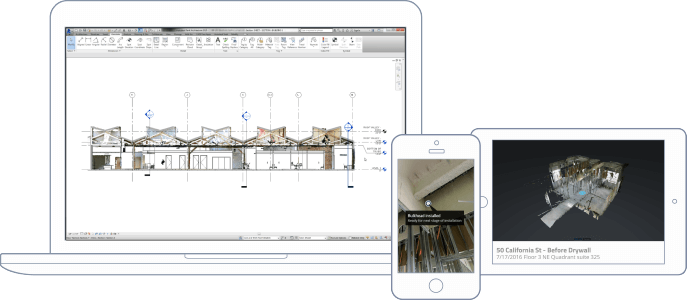
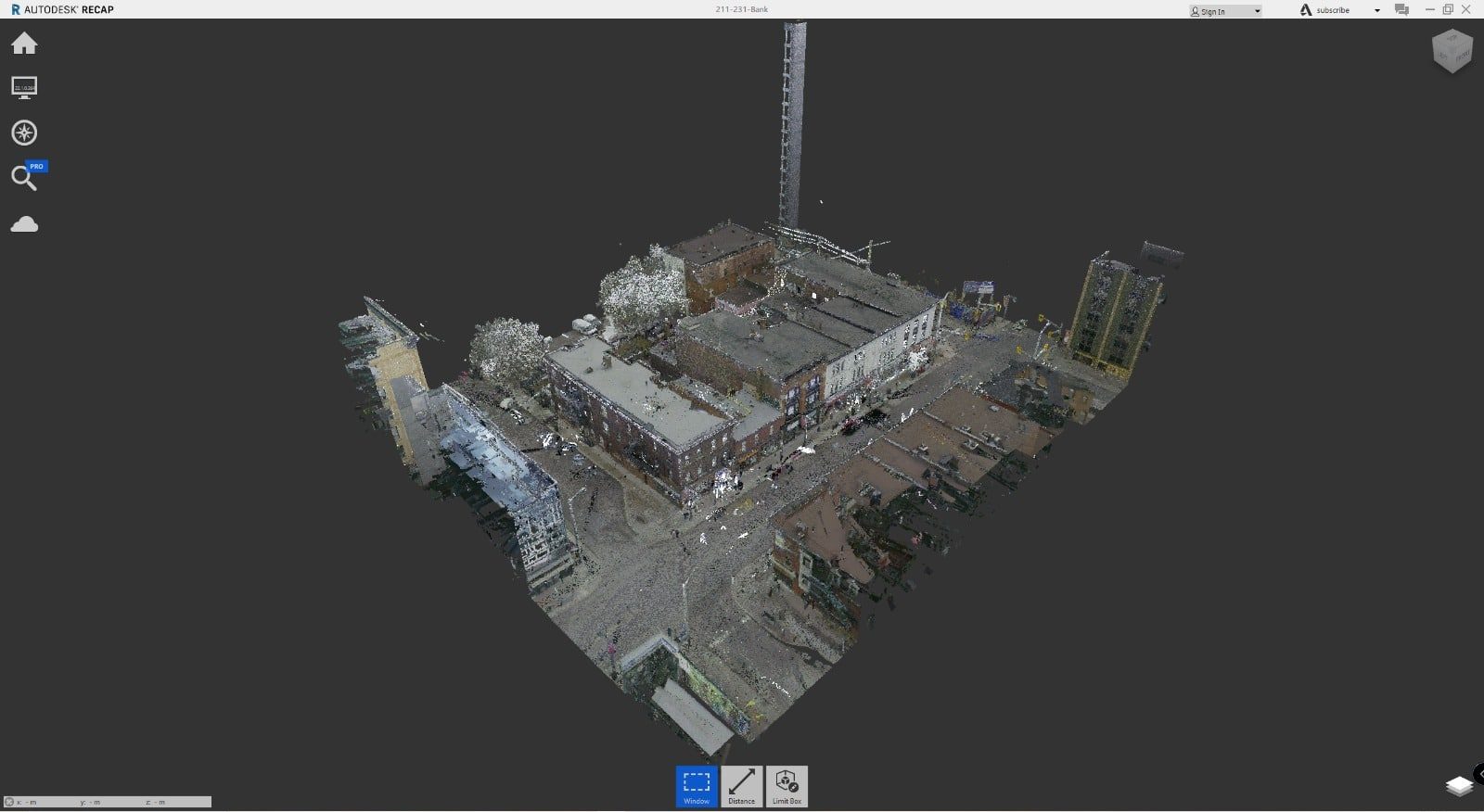
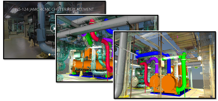
Immersive Job Site Models
We can capture 2D photography and 3D data from job sites, automatically stitching them into a complete, immersive 3D model of a real-world job site. Take this 3D model and annotate, share, and export the point cloud to Autodesk ReCap® or Revit®.
No Registration Markers Required
Our 3D scanning process is push-button simple. No registration markers and no manual alignment required. Everything is automatic!
Accurate Within 0.1%
Scanning is not only quick but also accurate enough to generate point clouds and polygons for as-builts and construction documentation.
Quickly Scan Current Conditions
3D scanning as-builts has never been easier. No need to set up registration markers before you scan, and your point clouds are automatically registered in the cloud for one less step.
Be Efficient, Measure While Offsite
No need for return site visits when you have a complete 3D model on your computer. Your as-built engineers can reference the complete space throughout the design process, collecting virtual measurements whenever they need to. As built documentation has never been easier.
Export Point Clouds Into Autodesk® Recap
You can easily export a registered, colored point cloud that is ready for Autodesk® ReCap. Use a point cloud as a real-world template to kickstart your as-built design process.
Reduce Virtual Design and Construction Costs
Make the scan the first step in your BIM process. Use it to to visually analyze a property, export the registered point cloud into your BIM modeling software, and start modeling from existing conditions.
Win More Bids With Better Documentation
Building owners want the construction of their buildings to be well documented. Provide them with superior construction documentation throughout the process. When you’re done, give them the files they need for long-term facilities management.
Keep your documentation costs low while still offering accurate, high-quality information.
3D Construction Documentation Without the Headache
With only a few simple scans, we can give you quick and effective milestone documentation. With both 2D photography and 3D data, it’s the best way to track key milestones and discover issues early.
All-in-One Documentation
A single scanned space can replace thousands of traditional 2D photos. With the immersive 360º walkthrough, documentation is both engaging and enjoyable. You can even zoom in and read detailed labels.
For when you absolutely need 2D photos, they’re easy to download from the scan. You can also get reflected ceiling plan images and high resolution floorplan images for even richer documentation.
Streamlined Collaboration Tools
Get stakeholders on the same page and give them the detail they need. Tag complicated areas with more information, such as MEP details beneath drywall. Highlight what’s most important with a Guided Tour.
Get the point cloud that accurately details current conditions and then export to Revit to compare with the original design.
Long-Term Value
Finally, turn over your documentation to the building owner for long-term facilities management. The owner will be pleased to have this easy-to-use treasure trove of information for future maintenance and renovations.

Virtual Stakeholder Engagement
Engage with stakeholders virtually with the same richness of experience as an in-person site visit.
Agree that reality capture is the future of AEC
By leveraging scan-to-BIM workflows, the AEC industry can experience up to a 60% reduction in data collection and processing time compared to traditional surveying methods.
Agree that having a 3D walkthrough is superior than other alternatives to communicate job site status.
Agree that Matterport has improved the way they communicate on projects.
Seamless Project Turnover
When the project is complete, we simply turn over your collection of 3D Spaces (captured at different phases) to the building owner and facilities manager as part of your turnover package. They’ll continue to use it for long-term management and maintenance.
1 - Scan Job site
Scanning 5,000 square feet (464 square meters) typically takes under an hour. No leveling, registration markers, or manual alignment required.
2 - Upload Data
With one click, upload your data to the cloud. Our powerful vision pipeline automatically aligns and stitches your 2D and 3D data into a complete textured mesh that’s as real as being on-site.
3 - Note, Share, Measure
Tag locations, create visual punchlists, and share 3D Spaces via a web link. Export assets to integrate seamlessly with your existing software.

Transforming Spaces Worldwide with 3D Models
Today, thousands of companies in over 150 countries use 3D immersive models to digitize any type of space, from University’s, offices for property management and hotels to factories and shops. Industries across the entire property lifecycle are realizing unprecedented value.

Trusted By:
Today, thousands of companies in over 150 countries use 3D immersive models to digitize any type of space, from University’s, offices for property management and hotels to factories and shops. Industries across the entire property lifecycle are realizing unprecedented value.
Our Experience Is Your Advantage
Hear what our incredible customers have to say!